Bird-watching Around Davis during the Holiday Season
Each fall more than a billion birds transverse California’s Central Valley as they travel south along the Pacific Flyway. As these birds travel down the valley, many stop in the Sacramento-San Joaquin Delta region south of Davis where thousands of bird-watchers come to meet them. Many people around Davis enjoy bird-watching, or birding, as a hobby. It’s an activity done worldwide as it’s a great way to learn more about and enjoy the natural world.

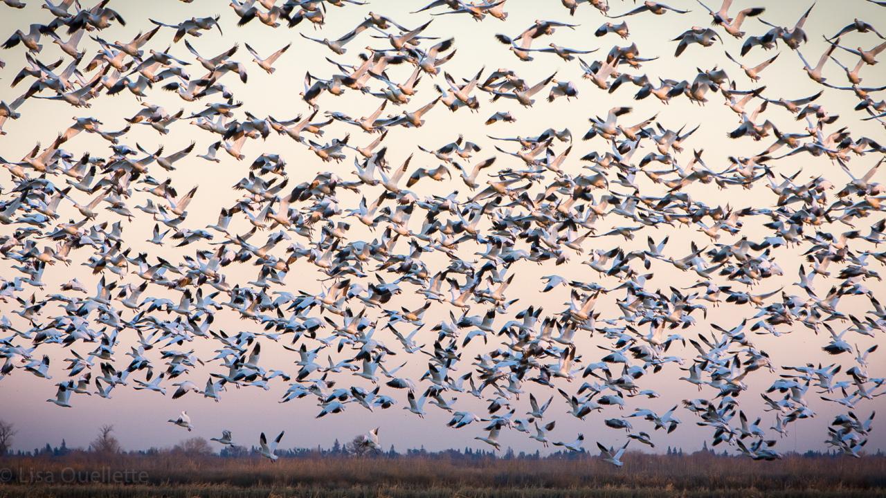
If you're out in the delta or among the fields this fall and hear a distant honking sound, your first thought might be to look around the fields for the familiar sight of Canada Geese. If that fails, you should look upward, as it’s not an uncommon sight during migration to see endless V-shaped flocks of Snow, Ross, Cackling, and Canada Geese in the air. Bird-watchers commonly report seeing anywhere from 100 to 10,000 Snow Geese flying through the delta fields. Although we’ve long since decided to dedicate this part of our state to agriculture, the birds still come. But this is just the start of the delta’s diversity. Flocks of geese are joined by cranes, ducks, swans, and ibis all making their way down the flyway every winter.
The area surrounding Davis has a plethora of parks, preserves, and roadside stops for observing all of the aural and visual wonders birds have to offer. Cameron Tescher, the former president of the University of California Davis Birdwatching Club, and now a professional Waterbird Biologist knows this well. “Davis really has so much to offer.” Said Tescher, “…the locality allows you to have good access to the valley oak woodlands and wetlands, the mountains' unique breeders, and a massive number of waterfowl.”
Some people go on hikes and walks for exercise, to see a waterfall, or to chat with friends. Others go outside to see birds! Bird-watching can be many things for different people. Most people get into birding to learn about what they see when they’re outside, often with an interest in conservation. Others birdwatch as professional biologists and conservationists, keeping track of birds and collecting data at certain sites and parks. For many, it becomes a sport. Birders will set goals to see as many species as possible in a specific region or time period. This leads to communities of people sharing their sightings online so others can go out to find the bird on their own.
What You Need
For your first time going out bird-watching all you’ll need is a way to see the birds and a tool to help you identify what you are seeing. You can start out by just using your eyes or a telephoto camera, but you will soon want binoculars.
Any binoculars with glass lenses will work, but if you're going out to buy a pair it’s helpful to learn about the naming system. Most bird-watchers use an “8x42” binoculars. ‘8’ is the amount of magnification and ‘42’ is how bright they will be. You should look for a pair with magnification between ‘7’ and ‘10’. A ‘10’ will zoom you in more with the trade-off that you’ll need very steady hands as the image will be small and shaky. A brightness number between ‘30’ and’ 50’ will give you a good view of any bird. The higher this number is, the brighter the image. ‘40’ is a good balance since a lower number often means the binoculars will weigh less, leading them to get taken out more often. Those with glasses should look for adjustable eyecups and diopters.
After you’ve gotten a pair of binoculars, you need to remember the golden rule. Never point your binoculars at other people or at the sun. While this is a lesson told to keep everyone focused and safe by Santa Clara Valley Audubon Society for their elementary school field trips, it’s good for everyone to remember.
The next step is learning what you're looking at. Many still recommend a hard copy bird ID book to learn how to identify birds, but everyone should first start with the Merlin Bird ID app by the Cornell University Lab of Ornithology. The app will prompt you to download your region's “bird pack” giving you access to hundreds of bird species profiles on your phone. Merlin ID’s five-step checklist takes the location, date, and time, and asks you what size the bird is, its colors, and where it was to generate a list of what species you probably saw. If one of the app’s descriptions matches what you observed, press “add to Life List” to add this species to the list of every bird species you’ve ever seen. The “Explore Birds” button is a great resource to use once you’ve started to learn some species names and want to see what else is out there at a certain location and date.
Most who call themselves birders keep lists. When out for a walk, a checklist will include every species one has observed and a count of how many individuals of each species there were. A checklist should never include a bird that you’re certain should be there or that you saw last time, only one’s current observations. You should start by keeping track in your head or with a notebook along with the Merlin Bird ID life list feature. Once you have a record of what you see in a certain spot, seasonal changes will become apparent and you’ll have a complete picture of your area's bird life.
Eventually, you may want to purchase a bird field guidebook to better study the differences between certain species. Popular guides include, “The Sibley Field Guide to Birds of Western North America”, which uses illustrations pictured here, and “The Kaufman Field Guide to Birds of North America”, which has photographs. It’s also worth going to a park's website before you visit to see if they have a list of birds seen. These site-specific lists are often sorted by habitat or season and can be very helpful.

Yolo Bypass Wildlife Area
The seemingly endless fields below the Interstate 80 Causeway are all part of the Yolo Bypass Wildlife Area, also known as the Vic Fazio Yolo Wildlife Area. The Yolo Bypass and Causeway were designed as a flood control project to contain any overflow from the Sacramento River. In the '90s, the state Fish and Game Commission designated the 16,000-acre area as a Wildlife Area, and the wetland habitat was rebuilt. The park still facilitates agriculture and hunting through rice farms and seasonal duck hunts. The publicly open portion is centered around a one-way auto tour route that provides visitors with multiple pull-outs and restrooms. It’s recommended to stop at whatever ponds currently have water or wherever you see birds.
What to See:
The Yolo Bypass’s landscape changes greatly as the amount of water changes seasonally. As the fields and ponds are filled in early fall, shorebirds ranging from the tiny Least Sandpiper to the tall Black-necked Stilt arrive at the preserve. Loud screeches in dry fields are made by Killdeer, which often seem invisible until they fly off to a new location. Searching through the clouds of calling Blackbirds will often reveal one or two Yellow-headed or Tricolored Blackbirds among the hundreds of Red-winged and Brewer’s Blackbirds. In the air, flocks of Sandhill Cranes and White-faced Ibis can be seen moving through the area, landing for only an occasional break.

Keep your eyes out for Northern Harrier hawks and Peregrine Falcons, both of whom will be watching the same birds you are as they look for a sandpiper or sparrow to eat. Higher up and in the surrounding trees, look out for Turkey Vultures and Red-tailed Hawks, and in the summer and fall, Swainson’s Hawks will join them. When driving between stops look out for the colorful Ring-necked Pheasant along with flocks of Savannah Sparrows and American Pipits.
Winter brings dabbling ducks followed by diving ducks. Dabbling ducks, like the common Mallard, sit on the water and feed near the surface. Diving ducks, such as the iridescent Bufflehead, rarely go on land and dive underwater to eat.
The Yolo Bypass Causeway is also home to a quarter of a million Mexican free-tailed bats every summer. During June through September, anyone can drive out to the entrance gate during sunset to see the bats flying out to hunt in the evening sky.
Directions and Rules:
The Park is open to the public from sunrise to sunset daily, excluding Christmas Day. Significant portions of the park are closed for different hunting seasons and select areas may be closed for farming throughout the year. The park is located on the west end of the Interstate 80 Causeway and is located at the western end of the Chiles Rd. frontage. At the “Vic Fazio Yolo Wildlife Area” sign, drive up the levee and continue to the auto tour route. More information about closures, along with park maps and guides can be found at the CDFW’s website (https://wildlife.ca.gov/Lands/Places-to-Visit/Yolo-Bypass-WA).
Cosumnes River Preserve
45 minutes south from Davis on Interstate 5 sits the region's largest preserve, the Cosumnes River Preserve, which is made up of almost 80 square miles split between seven land-owning partners. The Cosumnes River is the only river flowing into the Central Valley that’s not dammed and the preserve helps protect the lower reaches of this unaltered ecosystem. The preserve has a volunteer-run visitor center and an accessible boardwalk trail. Other portions of the preserve include the Valley’s best-preserved Woodland Tall Forest and the Staten Island Road farms. Staten Island is an agricultural area that The Nature Conservancy is using to successfully demonstrate that farmland can be economically valuable while also supporting wildlife. While most of the preserve is closed off to the public, the open areas are worth the drive.
What to See:
The preserve is known across the state as one of the best places to see Sandhill Cranes. The easiest spot is the park's Wetland Walk trail and boardwalk, which will reveal a few dozen cranes in the restored marsh. Those who want to see Sandhill Cranes in the hundreds can drive out to Staten Island Road where, according to the Nature Conservancy’s research, more than half of the Cranes in the delta spend their winter. Other large species that gather in the agricultural fields include the Canada, Greater White-fronted, and Snow Geese, along with massive Tundra Swans.
Back in the main preserve’s wooded marsh trails, look out for Belted Kingfishers, Green Heron, Great Blue Heron, and Egrets along the edges of the wetland. Hidden away amongst the forest you may see groups of ornate Wood Ducks while out in the ponds Northern Pintail and Northern Shoveler Ducks will be gathered in the hundreds. Other odd waterbirds can be seen like skinny Double-crested Cormorants drying out in the sun and the small-headed Pie-billed Grebe swimming underwater for food. Chirping noises from in the dense foliage are most likely made by Yellow-rumped Warblers and Black Phoebes flying around catching insects.
Directions and Rules:
The entire preserve is free to the public and open year-round, including holidays. The main preserve unit with a visitor center and interpretive trails is open from 9 a.m. to 5 p.m., while other units are open from sunrise to sunset. The visitor center is located at 13501 Franklin Blvd. in Galt and is open on weekdays from 9 a.m. to 3 p.m. It has bathrooms but no potable water. Staten Island Road can be accessed from the Walnut Grove Road exit off of Interstate 5. Visitors should respect farm operations and expect seasonal closures. More information can be found through the Cosumnes River Preserve partnership website at https://www.cosumnes.org/.
Putah Creek Wildlife Area and Lake Solano County Park
While the last two locations are prime wetland habitats, these two parks represent a riparian (along a stream) habitat. These parks both run along Highway 128 between the Lake Berryessa dam and the Lake Solano dam. This is another example of how most of our wild areas have been altered by humans. The area is popular with fly fishers, hunters, kayakers, and cyclists. Putah Creek Wildlife Area is on a 673-acre former cattle grazing area that’s now managed by the California Department of Fish and Wildlife. Lake Solano County Park was created by Solano County after the lake was created to open the area for recreation and now offers kayaking and camping.
What to See:
In Lake Solano, some familiar groups, or rafts, of waterfowl can be seen along with some species that prefer smaller bodies of water like the ornate Hooded Merganser, Wood Ducks, and Goldeneye. Look in the trees and along wires over the water for Double-crested Cormorants with their tall skinny bodies and orange beaks.
While the area may look mundane, it is known for having large populations of California Scrub-Jay and Lesser Goldfinch. Getting on the creekside paths may lead you to a more unusual resident, the Northern Pygmy-owl. This small predator is only 5 inches tall and can occasionally be spotted hunting during the day. Remember that an owl is a rare bird to see and spotting one should be considered a surprise, not an expectation.
While many of the most colorful avian visitors like Bullock's Orioles and Grosbeaks are only here in the summer, others have arrived over the winter. By listening for rustling leaves in dense thickets one can catch sight of a Varied Thrush with its metallic orange feathers. An even more festive winter bird is the red, green, and white Lewis’s Woodpecker, which will be found in oaks along with the many resident woodpeckers. The Acorn Woodpecker will make sure that no one misses them with their gregarious laughing calls and large family groups. These woodpeckers are one of the rare examples of a bird species that lives in a family group and shares food and nests.
Long-time bird-watchers will be seen at the top of Lake Berryessa’s Monticello Dam looking up the cliffs for some even rarer residents. Golden Eagles need large swaths of mountain land to have enough food to eat and a lucky birder may spot one soaring past. By scanning the surrounding cliffs very carefully a patient observer can see the bright orange Canyon Wren. The wren is barely 2 inches tall and loves holding onto the cliff side. If you can’t seem to spot one, listen for their trilling call coming from rocky outcroppings.
Directions and Rules:
Before going to any forested area in California everyone should familiarize themselves with poison oak’s shiny leaves in sets of three to avoid an unpleasant rash. Both parks were also burnt by wildfires in 2020, and staying on trails is important to avoid dangerous conditions.
Putah Creek Wildlife Area is accessed by un-gated roadside pullouts and is open all year. Lake Solano County Park’s open hours change seasonally. The park opens at 8 A.M. every day and closes at 5 P.M. except on Wednesdays when it closes an hour early. During peak season from April 1 through Sept. 30, the park is open two hours later on weekends. Bathrooms and services can be found at the Lake Solano County Park campground. More information can be found about Putah Creek at https://wildlife.ca.gov/Lands/Places-to-Visit/Putah-Creek-WA and Lake Solano at https://www.solanocounty.com/depts/rm/countypark/lakesolano.asp.
The area is located west of the town of Winters and can be reached from Highway 128 or by going west on Putah Creek Road and then turning right onto Pleasants Valley Road.
Birding for Conservation
The number of birds that migrate on the Pacific Flyway– over a billion– is truly astounding when looked at from a continental perspective. A report titled “Decline of the North American Avifauna” [51] brought together data from across multiple studies to show a complete picture of the region's bird population. The report, published in the journal Science in 2019, reported that since 1970 the United States and Canada have lost 3 billion breeding, or nesting, birds. This means that one in four of the total population of birds across the two countries has been lost in the last 50 years. This study was summarized by Cornell University on their “State of the Birds 2022” website [1] where the statistics are presented in an easy-to-interpret fashion. If the fun side of bird-watching doesn’t inspire someone to get involved, the scientific and conservation aspects may.
There are 674 species of birds that breed in the continental United States and Canada, and 529 have adequate long-term data the Science article was able to review. They saw that 90 bird species have lost 50% of their populations in the last 50 years. The report also shows that 70 of these species are still considered to be at a “tipping point” and are predicted to go extinct in the next 50 years if nothing is done.
The birds that haven’t headed on this downward slope are our aquatic migrants. The report synthesized population changes, or the number of individual birds in a year, by species and habitat to compare where conservation efforts are working the best. Geese and Swans, Dabbling/Diving Ducks, and Waterbirds are the three habitat groups trending upwards, with Geese and Swan populations skyrocketing upward at a 1000% positive increase in population over the last 50 years.
The entirety of the other habitat groups are losing population every year. Western Forest Birds, Shorebirds, and Grassland Birds are trending down at 5%, 33%, and 34% respectively. These groups also call the Central Valley home and need our help to be saved from extinction.

All of the tipping point species that live in the Central Valley are part of these three groups. Shorebirds like the American Golden-Plover, Lesser Yellowlegs, Pectoral Sandpiper, and Whimbrel along with Rufous Hummingbirds migrate through what’s left of their habitat in the delta region every year. Another sandpiper species, the Mountain Plover, spends its entire winter in what remains of the prairie habitats in the valley. One of California’s two endemic bird species, the Yellow-billed Magpie, is also on the tipping point list. The Tricolored Blackbird, easily mistaken for the common Red-winged Blackbird, is a declining resident species that was recently listed as Endangered.
While these statistics are frightening, the fact that they exist at all shows the amount of effort being put into saving birds. More than half of the data used for the study came from individual volunteer bird watchers submitting checklists from across the continent, all combined to create a complete picture of where specific species are and in what amounts. These casual birders record data through different projects. The Audubon Society’s Christmas Bird Count is the most famous, as it’s the United States longest-running citizen (or community) science project that in 2022 brought together 76,880 birders. Circles are drawn on the map across North America that are then surveyed once a year around Christmas Day with the goal of counting every bird in that region. The remarkable thing that sets the Christmas Bird Count apart from other projects is its age. While most ecological studies started in the 1960s or later, the Christmas Bird Count has 124 years of data.
Finding Community
If you would like to go out bird-watching while learning more from other birders, the Davis area has many opportunities. Students of UC Davis can join the university’s Birdwatching Club to go on group trips to local parks. Community members should check the Yolo Audubon Society (https://yoloaudubon.org/) and the Sacramento Audubon Society’s (https://www.sacramentoaudubon.org/) online calendars for beginner bird walks. The Cosumnes River Preserve and Yolo Bypass’s associated non-profits will also offer tours that can be found through their websites. All of these organizations will also offer scientific talks to those interested in conservation or learning about birds from different parts of the world. Those interested in learning about uncommon birds and getting hooked on chasing rare birds in the area can join one of the many Facebook groups, Discord channels, or email groups for our region.
If you are interested in going out to help look for birds as part of a Christmas Bird Count team, first go to the National Audubon Society website to find the map of where counts are located (https://www.audubon.org/conservation/science/christmas-bird-count). Once finding a location and date that will work (all counts take place the week before or after Dec. 25), search for the count through your local Audubon Society. All of the parks covered above have count circles happening every year and the town of Davis is covered by the Woodland-Davis count circle. Just reach out to the count coordinator and communicate your level of experience with bird identification and they’ll match you with a group that you’ll fit in with. Even when going out to do science, bird-watching is still a great activity full of surprises, and the more people you’re out with the more birds you’ll see. People also look forward to a commonly held tradition of a tallying dinner where everyone meets to share their sightings. The combination of conservation and community makes the Christmas Bird Count a great way to spend part of your holiday.

About the Author: Alden Hughes
I am a Senior pursuing the Environmental Science and Management major after transferring from West Valley College last year. I’ve always loved getting outside and exploring the world around me, especially when it meant I could spend time with friends or learn something new. After teaching myself bird identification and ecology during 2020’s stay at home rules I was Santa Clara Audubon Society’s Education and Outreach Intern, a lab assistant at West Valley focused on our bird taxidermy collection, and a nest colony surveyor for the San Francisco Bay Bird Observatory. I will always appreciate the many opportunities this hobby and study have brought me and I always enjoy sharing it with everyone else that appreciates the natural world.
Author's Note
I fell in love with birdwatching and the community surrounding it during the height of the Covid-19 pandemic. Picking up a book and a pair of binoculars to learn about the birds I saw in my backyard quickly turned into two internships, trips to scientific conferences, and many new connections. I’ve always loved what my mom calls “hiking with extra steps'' and going out and seeing birds is a hobby that I’ll have with me for the rest of my life. I wrote the paper below as my term paper for UWP Journalism taught by Professor Andersen. I took the opportunity of writing the article to familiarize myself with the local birdwatching groups and locations, all of which are parts of this paper.
References
- Rosenberg KV, Dokter AM, Blancher PJ, Sauer JR, Smith AC, Smith PA, Stanton JC, Panjabi A, Helft L, Parr M, and Marra PP. 2019. Decline of the North American avifauna. Science. 336(6461):120-124.